The Commands are the blue links located on the cards on the Location Information Panel. They provide users the ability to perform single property analysis, and gather more information on a property. Learn more about each command below.
|
|
Tip: The commands are found throughout the cards on the Location Information panel. You may need to click 'More' to see the full list of available commands on a given card. Each card can be expanded on the location panel.
|
Commands
|
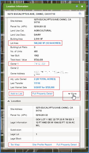
| Add To List |
Adds the selected record to the results list for the layer
|
| Adj. Lots Owned*** |
If the property owner owns adjacent lots, the number of lots and sum of their acreage will be shown in a blue link. Click the link to add the adjacent lots owned to a results list, and display on the map.
|
| Bird's Eye |
Opens a bird's eye, or oblique, aerial image of the selected property in a separate window.
Note: Bird's Eye is available in most major metropolitan areas.
|
| Copy Geometry |
Copies the selected record's geometry to another layer
|
| Create Map Exhibit* |
Allows users to easily create a map exhibit of retail logos in the surrounding area
|
| Design Cards |
Allows users the ability to specify the fields that display on the card. Formerly called Edit This Surface.
|
| Edit Attributes |
Allows changes to the field attributes for the markup layer
|
| Edit Geometry |
Allows the geometry of the selected feature to be edited, requires write access to the selected layer
|
| Exclude Area |
Allows the geometry of the selected feature to be excluded from the search filter. An optional buffer can be applied around the feature to exclude a specified radius around the feature.
|
| Document Images** |
Available as an add-on, allows users to access the Deed documents for properties.
|
| Find Comparables |
Allows the user to choose a property and use the attributes of that property to find similar properties. This functionality works across county lines.
|
| List Units |
Adds all additional records or units at the property to a list. This is an applicable command when there are multiple addresses or properties that are found on a master parcel. This is useful when researching shopping centers with a range of addresses or condos.
|
| Measure / Lot Area |
Allows the selected feature to have measurements turn on or off. The measurement is static and will stay on that parcel until the command is clicked again.
|
| Shared Documents |
Allows users to upload and share documents at a location, between everyone in their organization
|
| Shared notes |
Allows users to write and share notes at a location, between everyone in their organization
|
| Owner Lookup |
Selecting this option takes you to the website: www.CorporationWiki.com which provides Owner information from the Secretary of State
|
| Owner Portfolio* |
Adds all properties that share ownership to a list.
|
| Property Detail Report |
Displays a printable report of the full property details
|
| Search Area |
Allows the user to restrict the search to the selected property and an applied buffer, or radius, around the property.
|
| Seller Lookup |
Selecting this option takes you to the website: www.CorporationWiki.com which provides Seller information from the Secretary of State
|
| Site Profile Report* |
Allows the user to create a customizable PDF report that includes various details of a property including transaction history, property details, demographics data (within a defined trade area, or drive time), and more
|
| Tax Map** |
Available as an add on, this feature downloads an exact copy of the assessor tax map
|
| Transaction History |
Opens a new page with the transaction history for the property, shows all recent arms length and non-arms length transfers
|
* = Command is only available in the LandVision Commercial Real Estate & Builder Developer Editions.
** = Command is available as a premium add-on. Contact your Account Manager for more info.
*** = Command is only available in the LandVision Builder Developer Edition.
|
