The Large Area Buffer feature in LandVision™ allows users to quickly and easily capture all of the parcels that will be impacted by a project that will take place around a large subject area, such as a right of way. Capture up to 50,000 property owners to conduct notifications for major infrastructure projects spanning up to 100 miles.
Note: The Large Area Buffer/Corridor Query capability is available as an add-on to LandVision. Data extracts in excess of 2,000 records at a time may require a separate data license. Please contact your account manager for more information.
How to Run a Large Area Buffer
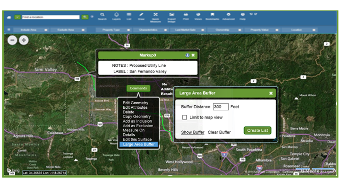
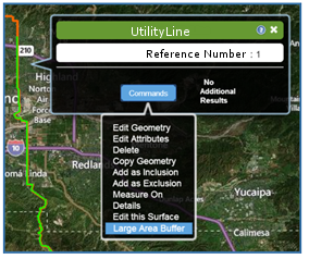
Click on your subject feature (e.g. utility line, drawn line, etc.) in the map to open the information window.
When the window appears, click on Commands. From the Commands menu, select Large Area Buffer.
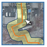
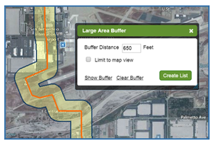
Enter in your desired buffer distance in the Large Area Buffer window (Max distance = 5,280'). Click Create List to generate a list of up to 50,000 parcel records.
Options::
Limit to Map View: Limits the parcel records returned in the buffer to those visible in the map view at the time when the buffer is ran.
Show Buffer: Displays the buffer on the map prior to creating the list of parcel records.
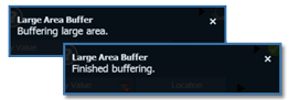
A notification window will appear in the top right corner. You will see of the Large Area Buffer's processing statuses. When the process finishes, click on the green check mark icon.
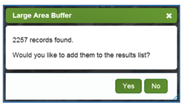
The Large Area Buffer results window will display the number of results found. Click Yes if you'd like to add them to the results list.
You can run a Large Area Buffer from any geographic layer including a loaded geospatial layer such as a planned utility line, or from layers created in LandVision™ such as a Markup.
What is the maximum line distance that I can run a buffer from?
The maximum line distance you can run a Large Area Buffer from is 100 miles. There is also a maximum number of parcel records that will be returned in a single Large Area Buffer. If this maximum number is reached then you will need to break your buffer into smaller segments.
What is the maximum allowable buffer distance?
The maximum buffer distance for a geographic feature is 5,280', or 1 mile. If you enter a buffer distance greater than 5,280' then you will be notified to change your distance to an allowable distance.
What is the maximum number of parcel records retrieved in a single buffer?
The maximum number of parcel records retrieved in a single buffer is 50,000. If your buffer area intersects more than 50,000 parcel records, then you will be notified that your buffer exceeds the max records. You will still be able to generate a list from the 50,000 records picked up in the buffer, but there will be a gap in the total number of records intersected by the buffer and the number in the list. To reconcile this gap you will need to break your buffer into smaller segments.
Can I export the results of a Large Area Buffer?
The resulting parcel records from a Large Area Buffer can be exported using two methods:
Export for Mail Merge: Maximum allowable records (50,000)
Export to CSV: Top 2,000 records (same as the standard LandVision™ Property Search)
Note: Data extracts in excess of 2,000 records at a time may require a separate data license. Please contact your account manager for more information.
This video provides an overview of the Large Area Buffer command in LandVision. By watching this video you will learn how to quickly and easily capture all of the parcels impacted by a project within a large subject area, such as a right of way.