|

|
|
INTEGRATION WITH VIRUTAL EARTH'S
|
|
OBLIQUE IMAGERY
|

|

|
|
INTEGRATION WITH VIRUTAL EARTH'S
|
|
OBLIQUE IMAGERY
|
|
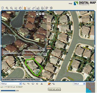
For properties identified in CityGIS, you can also view Microsoft's Virtual Earth
Oblique imagery (only available in select areas) without the inconvenience of leaving
CityGIS. |
|
|
View properties in higher resolution and from multiple vantage points (North, South,
East, West).
To use:
|

|
|
QUESTIONS?
|
If you have questions or problems using these new features, contact Digital Map's Customer Success Team at:
If you'd like to view this document in the future, click on the "What's New" link in the upper right hand corner of your CityGIS screen.