ParcelStream™ from Digital Map Products
Powering Accurate, Interactive Web Applications
ParcelStream™ from Digital Map Products allows web developers to build accurate, highly interactive applications without the maintenance issues or prohibitive up-front costs associated with purchasing bulk parcel data. ParcelStream™ is an application that provides delivery of hosted parcel data.

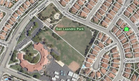
Parcel lines displayed in Microsoft® Virtual Earth™. Easy to integrate and with minimal code. |
Why Use Parcel Data?
Parcel data enhances the accuracy of mapping applications by tying addresses to latitude and longitude lines, which are definite location indicators. Integrating parcel data allows applications to:
- Zoom in to a particular property rather than a general area
- Provide more accurate directions
- Tie information directly to a property
- Retrieve information by clicking on the property
- Display parcel labels, such as the parcel number
The ParcelStream™ Difference
Parcel data without map integration is less useful than an HTML document without a web browser. Not only is bulk parcel data expensive to acquire but it also consumes additional resources to structure and maintain it. ParcelStream™ is different:
- ParcelStream™ is an application
- No GIS expertise necessary to enhance your application
- Developed to run on Microsoft® Virtual Earth™
- Start displaying parcels immediately with a few simple lines of code
- Maintained to be compatible with new versions of Virtual Earth™
- Continually enhanced capability
- Parcels are stored and maintained by Digital Map Products
- No need to tie up additional staff or resources
- Focus on core competencies
- Delivery method is compliant with intellectual property rights
Why Use Digital Map Products for Parcel Data?
Parcels are Available on a Metro-centric Basis
Digital Map Products focuses on collecting the most valuable parcel data first. Other companies collect the data that is most available or most affordable and skip over expensive but important areas.
More than 10 years experience aggregating parcel data
Digital Map Products was initially launched as a joint venture of Thomas Bros. Maps and Psomas in 1996. Psomas is the largest privately owned survey engineering company in the Western United States. As a survey company, the handling of parcel information is a core competency that has been passed along to Digital Map Products.
Created the first ever public/private partnership for data sharing
In 1997 Digital Map Products worked with a consortium of California counties to create the legal framework allowing private companies to use parcel data created and maintained by government agencies. That framework has become the basis for many of the licensing agreements used throughout the country today.
The largest source of parcel data available
With more than 100,000 registered users of Digital Map Product’s parcel data repository, no other company comes close. This list includes public sector agencies, as well as private sector companies representing a large cross-section of markets. Digital Map Products’ success in providing parcel data is best illustrated by its relationship with Cyberhomes, a real estate website with millions of hits per month.
Additional Data Options
Digital Map Products has access to countless data sets that can be easily tied to parcel information and integrated with your application. Contact Digital Map Products to discuss adding data to a ParcelStream™ subscription.
For more information about ParcelStream™, email sales@digmap.com or contact us.
Learn More:
Microsoft® Virtual Earth™ is a trademark of Microsoft® Corporation in the United States and/or other countries. ParcelStream™ is a trademark of Digital Map Products.