|
LandVision™ Help > Documentation > Layer Options
|
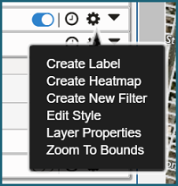
The Layer Options Include:
|
| Layer Options Icon |
Access the layer options by clicking the gear icon next to the intended layer, on the Layers Panel.
|
| Create Label |
Provides the ability to create labels to display data on the map.
Tip: Create a label from the parcels layer to display the APN or Owner Name over each parcel.
|
| Create Heatmap |
Visualize the layer as a Heatmap. Learn more here.
|
| Create New Filter |
Create a new filter to search the layer or dataset. Learn more here.
|
| Edit Style |
Provides the ability to edit or change the layer style.
|
| Layer Properties |
This option opens up the Layer Properties Window, allowing you to organize your data. Assign layers to existing groups, or create new groups. You can even set the zoom levels that layers will turn on/off at.
|
| Zoom to Bounds |
Sets the map extent to the boundary of the selected Layer.
|
| Tell us what you think |
Feedback
|
