TIMEVIEW SATELLITE IMAGERY


GovClarity® Help > Documentation > TimeView Satellite Imagery

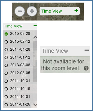
The TimeView tool in GovClarity enables you to view the most up to date Satellite imagery available in your area. This feature allows you to view current satellite imagery as well as access a database of historical satellite imagery that appears right on your map with the click of a button.

TimeView is available as an add-on to any GovClarity account. For pricing and more information, visit our Request TimeView Information page or contact your account manager.


Using TimeView in GovClarity


  1. The TimeView button can be found in the bottom right corner of your map next to the zoom in and zoom out buttons.

  2. To see the available imagery for your current map view click on the Time View button. This will expand a list of dates you can select from. These dates are the capture dates for the corresponding satellite imagery.

    Note: For performance and scalability reasons, Time View automatically turns off when you've zoomed so far out that it would be of negligible value. Zoom in to enable Time View imagery.

  3. Click on a date to view the corresponding satellite imagery on your map. A green check mark TimeView Check Mark will appear next to the date to indicate it is selected.


  4. Tip: Satellite photography captures a limited area at a time so the imagery available varies based on the area you are viewing. Moving the map may cause different dates to become available. Minimize or expand Time View to refresh available dates.

    Note: You can select only one date at a time.

  5. To view a different date simply click another one from the list to have the corresponding satellite imagery appear.

    Note: TimeView imagery is fully compatible with other layers.

TimeView interface in GovClarity

Current GovClarity Aerial Imagery
Current Aerial Imagery in GovClarity

TimeView Satellite Imagery
Satellite Imagery in GovClarity


TimeView Considerations
  • TimeView imagery is satellite imagery, which is different from aerial imagery. The resolution will generally be less than the base map aerial imagery and will look less refined due to fewer post-processing procedures. Its primary benefits are its currency and frequency.

  • TimeView also differs from aerial imagery in that it is not contiguous for a given area. It is captured in strips. As you turn on a given satellite image, you may run into the edge of the image. This is normal and expected. If you encounter an edge of an image, simply refresh your TimeView available list and select another image set from a similar timeframe.

Return to Top

Related Information


© Copyright 2018 Digital Map Products About DMP | Contact Us