VIEW PROPERTIES IN GOOGLE EARTH™


GovClarity® Help > Documentation > View Properties In Google Earth

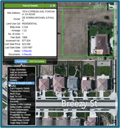
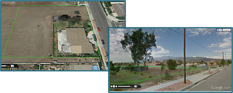
GovClarity now offers an integrated 3D view of properties in Google Earth™. To further your map analysis, the property boundary line of a parcel that you identify in GovClarity displays in the Google Earth™ 3D environment.

Requirements:

  • Download Google Earth™
  • If you are using Microsoft Internet Explorer®, set to program compatibility mode. See Internet Explorer® Help for instructions on how to activate compatibility mode.

Downloading Google Earth™


GovClarity integration with Google Earth™ requires the Google Earth™ plug-in. To download Google Earth™ if it isn't already installed on your computer:

  1. Go to the Google Earth™ website:http://www.google.com/earth/index.html.

  2. Click on Download Google Earth™.
Note: The Google Earth™ plug-in does not include all of the features in the Google Earth™ desktop application.

Viewing Parcels in 3D


  1. Identify the property in GovClarity that you want to view in Google Earth™, either by clicking or running a search.


  2. Click on Commands at the bottom of the Parcel Details window.
View in GoogleEarth option
  1. Click View in Google Earth™ on the menu. A new window opens which displays the parcel in the Google Earth™ 3D environment with the property boundary line from GovClarity displayed.


  2. Drag the Street View iconGoogle Icon Street View to the parcel. The 3D street level view also includes the property boundary line from GovClarity.
Google Earth Parcel and Outline
Note: To view an area of interest in Google Earth™ instead of a specific property, right-click on the map in GovClarity, and then click View in Google Earth™ in the menu (See Related Documents). ViewInGoogleEarth

Return to Top

Related Information


© Copyright 2018 Digital Map Products About DMP | Contact Us