|
|

|
LANDVISION 8.10 RELEASE
| LandVision Help > What's New > 8.10 Release | |||
|
Welcome to the 8.10 release of LandVision. For this release, we've focused on improving your efficiency and workflows, and are pleased to introduce the following:
Keep reading below for more details on what's new in the latest release of LandVision and for links to additional information on how to use these new features. |
|||
| |||
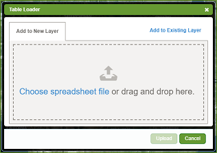
Drag-and-Drop Spreadsheet Loading
One of the beautiful and useful things about LandVision is the ability to visualize and analyze your own data, in addition to ours. We're excited to introduce a new drag and drop interface, making loading your data easier than ever! With this, also comes the following enhancements:
Visit the link below to learn more about this feature: |
|
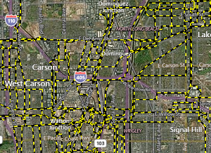 Pictured: Active pipelines in the city of Los Angeles
|
Enhanced Integrated Esri Feature LayersWhen we first introduced Integrated Esri Feature Layers for our applications, the data presented could only be viewed and accessed by identifying specific features. With this update, you're now able to search the data that's coming from an ArcGIS server just like you would with any other data set, including the ability to:
Visit the link below to learn more about this feature: |
Bulk attribute Changes to your DataUpdating information for a layer is now easier than ever. The Results List now includes a new command, providing the ability to update the information in a custom layer all at once This can be performed by loading a layer into the Results List (whole layer) or by searching for specific sites and adding them to the list. Visit the link below to learn more about this feature: |
Powerful New Search Tools
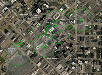 Pictured: Parcels that are over 1/3 of an acre with residential zoning that are within 500 feet of a transit stop.
|
New Search Capability
This new search capability takes something that has historically been limited to a GIS professional and makes it an everyday workflow. You are now able to search for desirable features in one data set, then limit the search of more data sets to those areas in just a few steps.
Include Areas in Search |
Filters and StylingWhen searching for a point layer that includes a custom style, that style will continue to be represented in the search results. This includes custom icons and ramped styles and is limited to point layers. |
|
General Usability Enhancements & Fixes
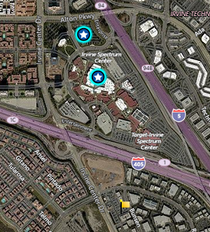
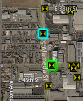 Pictured: A search result with a blue highlight and a selected feature that shows a green highlight.
|
We've taken the feedback from our users and made the following enhancements to ensure an easier and better experience in LandVision:
Visit the links below to learn more about this feature: |
Enterprise Account Management
Single Sign-On
Accessing LandVision has never been easier. With this release we are now offering the ability to access LandVision with your standard login and password that you use at the office.
|
Data Updates
|
While our customers have been awaiting the latest release of LandVision, they have already had the benefit of experiencing the following updates:
|
|
Return to Top |
| © Copyright 2018 Digital Map Products |