LANDVISION SPRING 2017 RELEASE
|
LandVision
Help >
What's New > Spring 2017 Release
|
|
Welcome to the Spring 2017 release of LandVision. With this release comes:
- Enhanced application performance
- Exciting new changes to the User Interface
- New tools to tailor the LandVision interface to display information based on your preferences
- Brand new tools to lend insights into your market, helping you to visualize and understand opportunities
- The ability to display your Esri Feature Layers in LandVision
- Continuous updates to the data!
Keep reading below for more details on what's new in the LandVision Spring 2017 release and for links to additional information on how to use these new features.
|
Enhanced Performance
|
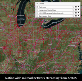
With the introduction of Streaming Feature Layers (SFL), searches, map exploration, and data displays are lightning fast! Our new SFL technology brings near instantaneous parcel boundary load times making panning the map, changing areas of interest, or even investigating multiple metros a breeze!
|
|
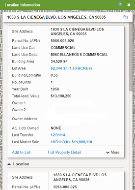
Simplified Access to Information
New Information Panel
The new Panel and Cards interface introduces significant improvements to how information is presented, making it easier to locate necessary information at a moment's notice. The data that was previously found on multiple layers or balloons can now be found on the relevant cards within the Location Information Panel. This change doesn't stop at the presentation of data, the commands have also been relocated to the cards that best correlate to their functionality.
Visit the links below to learn more about this feature:
Panels & Cards Interface | Commands
|
|
|
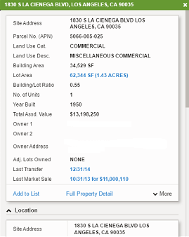
Comparison Panel
Gain a deeper understanding of a feature, or compare two different features within the same layer using the new Comparison Panel. The Comparison Panel is generated via the Copy to Compare command which generates a duplicate panel containing the information that's presented on the Location Information Panel. Once the Comparison Panel is generated, the information within it remains static leaving the Location Information Panel available for further navigation, discovery, and research.
Visit the links below to learn more about this feature:
Comparison Panel | Location Information Panel
|
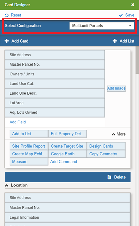
Property Specific Information Panels
With this release comes the addition of Panel Profiles. We've combed through the information and have introduced different Panels based on land use, adding efficiency to your research. If there's something missing that you need to see, that's fine. Many of our customers use LandVision in different ways and we support that! Each user can customize the individual Panels for themselves, or share the map composition, including Panel Profiles with others. Check out Card Designer to create your own Panels today!
Visit the links below to learn more about this feature:
Panels & Cards | Card Designer
|
|
|
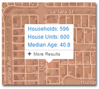
Tooltips
The ability to quickly navigate the map and make efficient decisions is taken a step further with the introduction of Tooltips. A Tooltip is generated by simply hovering the mouse over a single or multiple intersecting polygons, points, or lines to instantly view relevant details. We realize that the information that's represented in the Tooltip may differ based on your project. For this reason, we've included the ability to edit the Tooltip. Research and find opportunities like never before with LandVision's new Tooltips!
Visit the link below to learn more about this feature:
Tooltips
|
|
New Tools for Market Insights
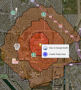
Trade Areas
Visualizing your market just got even easier! Our customers using the Builder Developer Edition or the Commercial Real Estate Edition now have new Trade Area capabilities. No longer limited to just our Points of Interest layer, Trade Areas can be generated from any location on the map with a simple right click. Try out the new Trade Areas feature today and get a better understanding of your market!
Visit the link below to learn more about this feature:
Trade Areas
|
|
|
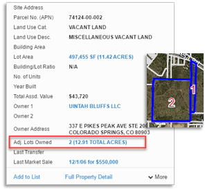
View Adjacent Lots Owned
We've taken the guess work out of finding which adjacent lots are owned by the same entity. Exclusive to LandVision Builder Edition, at the click of a button you can quickly add all adjoining parcels with the same owner to a list and view them on the map. It's never been easier to perform an assemblage search!
Visit the link below to learn more about this feature:
Commands
|
Regional & National Filters
|
|
New large scale Search Forms have been introduced to LandVision Commercial and Builder Editions. The new Regional Commercial Property Search allows our users to perform commercial property searches over an entire metro area. The new Major Brands Search for LandVision Commercial and the Builder Sites Search for LandVision Builder takes this same capability to a nationwide scale! Now you can understand where your competitors are expanding and where they're missing opportunities as easily as checking a box.
Visit the links below to learn more about this feature:
Search Filters | Points of Interest Data
|
|
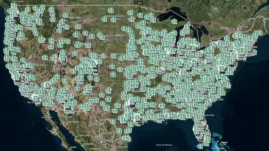
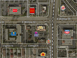
Major Brands Layer
While we've retained our standard POI Layer, the new Major Brands Layer includes over 1,600 brands! Each brand has an associated logo, providing a simplified understanding of the complementary and competitive retail landscape. Check out this layer for a high-level analysis of an area and cleaner presentation of opportunities!
Visit the link below to learn more about this feature:
Points of Interest Data
|
|
Integrate Your Server Hosted Data
|
Introducing LandVision's Integrated Esri Feature Layers, the solution for customers that have Esri servers and would like to access the map services within LandVision. Now, layers housed on an Esri server, whether it's on premise or in the cloud, can be viewed in LandVision subscription accounts.
Your Esri data is served directly into the LandVision client application running in your browser and is presented to your users, including any content or style changes that are made on the server. Also, important to many, your data is maintained private and confidential to your organization with this model. Contact us to see how the Integrated Esri Feature Layers can be leveraged alongside Digital Map Products' data all within one application.
* The Integrated Esri Feature Layers is an add-on for LandVision products. Contact your Account Manager for more information if you are interested in this new capability.
Visit the link below to learn more about this feature:
Integrated Esri Feature Layers
|
|
|
New Mobile Capabilities!
Connect for LandVision CRE
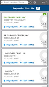
Connect for LandVision Commercial Real Estate Edition has received significant enhancements, including official support for Android phones! Customers leveraging this feature can look up and track property information from the field, keep tabs on properties, and locate the nearest 25 properties. Don't fall behind when it comes to understanding your market and tracking your deals. Check out LandVision Connect today!
Visit the links below to learn more about this feature:
Connect for LandVision CRE | MySites
* Contact your Account Manager for more information if you are interested in this capability.
|
|
|
|
|
Data Updates
|
And while you may need to wait for a release to experience our powerful new features, data updates are always being processed and published to LandVision. As a LandVision subscriber you get a continuous stream of new and refreshed data. For example:
- Over the past six months, DMP has sourced, secured, and processed parcel geometry updates from Counties covering over 30 million parcels.
- Just since November, nearly 51 new counties, totaling over 1 million parcels, have been added into LandVision!
- We've improved your ability to locate addresses in remote locations via the Locate Tool.
|
|
|
|
|
© Copyright 2018 Digital Map Products
|
|
|
