LANDVISION™ VERSION 8.18


LandVision™ Help > What's New > Version 8.18

Digital Map Products is excited to announce the release of a new version of LandVision™, version 8.18. This new version includes several usability enhancements, as well as some great new features and is the result of your valuable user feedback.

Now, in version 8.18, you can more easily add and work with your own data in LandVision™. We've simplified the drawing tools, added the ability to attach notes and documents to parcels, and given you more options for working with your layers.

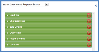
We've also enhanced our search and results list features with a new advanced property search form, improved Address Labels, and expanded the inclusion / exclusion search options. You can even link out to Google Earth™ from LandVision™ to evaluate your property from a street level or terrain perspective.

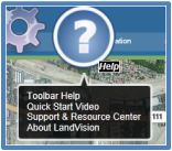
Further, LandVision™ version 8.18 includes several convenience features such as support for additional internet browsers, expanded feature help documentation, and auto-save of your map.

Keep reading below for more details on what's new in LandVision™ version 8.18 and links to additional information about how to use these new features.

WORKING WITH YOUR DATA


LandVision™ 8.18 has several new features and enhancements to existing features that make it easier for you to add and work with your own data on the map. With the Add Notes and Attach Documents features you can now link your comments, information and related files directly to a parcel in LandVision™. Adding your own notes and documents to parcels puts all the information about a property at your fingertips, enhances collaboration, and saves time.

We've also simplified our drawing tools and markup layer behavior so you have greater flexibility to create multiple markup layers, quickly toggle among active markups, and save groups of markups into their own layer. Markup Labels are easier to use and can be rotated, display multiple lines of text, and fixed to real-world units so your labels are appropriately sized when you zoom in or out. The new LandVision™ also features an improved Site Plan Overlay tool that allows you to zoom in and out and pan the map while in edit mode. And the ability to toggle off Bing™ Map Labels to display only aerial imagery gives you another backdrop option for map making.

With our new Layer "Save As" and "Copy As" commands you can readily move layers you've created in LandVision™ or imported into LandVision™ among folders and create copies. This helps with managing versions of your layers and sharing them with colleagues.

Visit the links below to learn more about these new features:

Add Notes | Attach Documents | Drawing Tools | Markup Labels | Site Plan Overlay | Saving Layers

SEARCHING & RESULTS LISTS


Because property search is such a critical function to our users, we're always looking for ways to streamline searches and working with results in LandVision™. LandVision™ 8.18 has a new filter, Advanced Property Search, which lets you define your search criteria by unique land use types and provides location options to limit your searches to specific areas. We've also added the ability to focus your searches using a drawn line as an Inclusion criteria. This is helpful if you want to target your searches along a boulevard, freeway, or rail line. You can also buffer line inclusions to a specified distance.

Version 8.18 includes an update to our Address Labels feature to improve mail deliverability. You can also link out to Google Earth™ from LandVision™ to evaluate your property from a street level or terrain perspective.

Visit the links below to learn more about these new features:

Advanced Property Search Filter | Inclusion/Exclusion | Google Earth™

LANDVISION™ SUPPORT


The latest version of LandVision™ incorporates several new features that will make using LandVision™ even more convenient. LandVision™ is supported on additional internet browsers, including Mozilla Firefox and Internet Explorer 8. To help you get the most out of the product, we've significantly expanded our in-product help and feature documentation. You can click on the ? on selected in-product features and visit our LandVision™ Help Center. We've also added a new feature that auto-saves your map, markups, and location so when you log back into LandVision™ you can pick up where you left off.

Visit the links below to learn more about these new features:

Supported Browsers | Documentation | Map Auto-Save


Return to Top


© Copyright 2018 Digital Map Products About DMP | Contact Us