LANDVISION™ VERSION 8.29
|
LandVision™
Help >
What's New > Version 8.29
|
|
Digital Map Products is excited to announce the release of a new version of LandVision™, version 8.29. This new version includes usability, search and sharing enhancements and is the result of your valuable user feedback.
In version 8.29, our enhanced usability and search options provide you with quick access to the information required for your research, analysis and presentation needs. We've also made it easier to work with your search results and given you additional ways to visualize data in LandVision™.
Further, the latest LandVision™ now includes content sharing, making it simple to share data with other users in your organization.
Keep reading below for more details on what's new in LandVision™ version 8.29 and for links to additional information about how to use these new features. Please note that certain features marked with an asterisk * are not available in LandVision™ Professional Edition.
|
ENHANCED USABILITY
|
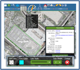
LandVision™ version 8.29 has a new Measure Tool that let you quickly obtain measurements of a parcel or any feature on the map. From the Drawing Tools icon or the Commands menu, you can draw an area on the map and take its measurements. The Drawing Tool will continue to take measurements until you select the 'Measure Off' option.
In addition to the Measure Tool, version 8.29 includes redesigned Drawing Tools featuring more efficient editing of markups and an intuitive formatting toolbar that appears as soon as you select a map drawing. Creating your own custom maps in LandVision™ is easier than ever.
|
|
|
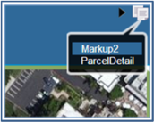
Also updated in the latest LandVision™ is how to identify features on the map when there are multiple identifiable data sets at your location of interest. Previously, this was done with the 'At this Location' button on the Details Window. Now, when you click on the map and there are multiple items in the same location, you will see a menu list appear in the upper right hand of the screen that lets you select the data set you'd like to identify.
|
|
|
Visit the links below to learn more about these new features:
Drawing Tools
| Measure Tool | Identify Options
|
|
IMPROVED SEARCH
|
Because property search is such a critical function to our users, we're always looking for ways to streamline searches and working with results. We've enhanced the LandVision™ Parcel Overview window, by adding clickable fields* to access further information about the parcel. A clickable APN now displayed in the window takes you to the expanded parcel details, while the Owner field links to the CorporationWiki.com profile.
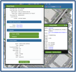
Also improved is the Parcel Details window. With its new design that includes expandable and collapsible sections*, it's easier to navigate and view related data. This window also provides clickable fields* to access detailed FEMA and Wetland hazard data. Both Parcel Detail window improvements provide significant time savings by making deeper information available in a single click.
|
|
|
The filter functionality in version 8.29 has been enriched with the addition of the following to the filter bar and search options menu: 'Select All,' 'Deselect All' and 'Clear Filter.' These enhancements reduce the time and effort required to conduct your searches and provide a quick way to reset all your forms.
Lastly, we've enhanced the search logic for APNs in our Locate Box, which will return more accurate results, even when there are discrepancies in the format of entered APNs, and particularly in those with leading or trailing zeros.
|
|
Visit the links below to learn more about these new features:
Parcel Details*
| Searches & Filters | Using Locate
|
|
ANALYZING SEARCH RESULTS
|
An exciting addition to LandVision™ is the ability to save and open results lists*, which has been a popular user requested feature. You can also open and save your layers as lists so you can work with any data set in both map and tabular form. Now, you can quickly identify trends, compare search results over time, and make more informed decisions based on your saved data.
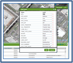
LandVision™ version 8.29 features a results' lists enhancement which allows you to enter in custom names for standard data fields. You can also drag or drop any field to another location, and remove any field with one click. Now, you can quickly customize your lists in a single window, and tailor your fields so they are more meaningful to your organization or audience.
|
|
|
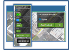
We've also simplified the LandVision™ Search Results Box. The new Search Results Counter puts more tools at your fingertips for working with your search results. It's a breeze to evaluate and present your search results by visually enhancing your display with our Styler Tool, or to organize and sort your data by adding it to a results list.
|
|
|
Visit the links below to learn more about these new features:
Saving Results Lists*
| Results List | Search Results Box
|
|
SHARING MADE EASY
|
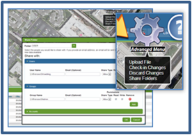
Located under the Advanced Menu, users can now share their content with individual users, groups, or everyone in their LandVision™ account. You can share layers and styles, map compositions and saved results lists. By enabling sharing*, users can experience significant time savings and improved collaboration with their team members.
|
|
|
Visit the links below to learn more about these new features:
Content Sharing*
|
|
|
© Copyright 2018 Digital Map Products
|
|
|
