CITYGIS™ VERSION 8
|
GovClarity® Help > What's New > Version 8
|
|
Digital Map Products is excited to announce the release of CityGIS™ Version 8. Version 8 is all new and provides a completely redesigned user interface. Version 8 also introduces exciting new functionality and enhances several of your favorite go-to features from CityGIS™ Version 7.
In Version 8 you'll experience CityGIS™ in a whole new way with the enhanced, easier to use mapping interface that allows faster access to critical information. Built on the popular Microsoft® Bing™ Maps platform, you'll be able to jump right in and navigate the map with familiar navigation tools and keyboard hotkeys.
CityGIS™ Version 8 is completely browser plug-in free (no Java or enhanced print plug-ins), works across multiple browsers and platforms, and features a whole host of administration tools to help you self-manage your users and account. All of the new features make it easier to bring a map perspective to your daily workflows, and let you extract the maximum value from important location-based data by capturing, combining, and analyzing it in CityGIS™.
|
Other enhancements in CityGIS™ Version 8 include the ability to edit and maintain data layers within CityGIS™, you no longer need to extract data layers into editing software. Loading and publishing your data has never been easier in Version 8. You simply load the data through the built-in Data Loader tool and the data can be immediately made available to the entire account.
Additionally, CityGIS™ Version 8 incorporates all new search capabilities including dynamic results that update as you pan the map, expanded search forms with more property attributes, plus the ability to create and save your own forms. Version 8 introduces new ways to customize CityGIS™ to fit your individual or municipalities' needs.
Keep reading below to learn more about what's new in CityGIS™ 8.
|
|
|
Visit the links below to learn more about these new features:
New Interface | Searching | Working with Data | Address Mgmt | Buffer Searches | Admin Tools | Other Features | System Recommendations
|
|
|
The new CityGIS™ Version 8 user interface has been completely redesigned combining the best of Digital Map Products' enhanced mapping and information tools and the Microsoft® Bing™ Maps platform. You'll benefit from a larger, easier to navigate map that allows for faster retrieval of property information and other important data layers. Layer information is now displayed in multiple forms including an in-map quick access information window for faster data analysis.
|
|
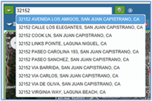
The search capabilities in CityGIS™ Version 8 are significantly improved. You will find what you are looking for in a better way with its on-the-fly criteria modifications and dynamic results.
|
|
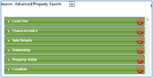
All searches are located in one menu including Property Search and Property Sales, which let you define your search criteria by site characteristics, owner name, assessed value and even limit your searches to specific areas such as the City Boundary. Add to that, the ability to create and save your own custom searches, the ability to add multiple inclusionary and exclusionary geographic constraints, the ability to change your displayed search results style, plus the ability to obtain up to 20,000 search records and you will agree CityGIS™ Version 8 will help you more effectively manage your municipality.
The Results list has been improved in a number of ways to maximize efficiency and improve data visualization.
- Define when you want to view the list
- Interactive results list; sort, add and remove fields
- Export tabular data
- Create Address Labels
- Export to Mail Merge
- Print or save data
|
|
|
Visit the links below to learn more about these new features:
Property Search Filter | Results List | Create Filter
|
|
|
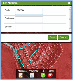
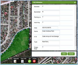
Version 8 of CityGIS™ utilizes the power of HTML5 to allow for in-browser edits of data layers. Through an enhancement to the Drawing Tools, you can choose any existing Agency layer to draw new points, lines or polygons and can then complete associated feature attributes. Similarly, you can create new layers through the drawing tool as well. You can edit existing layers through the Edit Geometry and Edit attributes commands, accessed through the information window associated with each layer. Through these new features, you are empowered to maintain and create layers associated with your specific roles and knowledge which maximizes efficiency and minimizes error.
|
|
|
As in CityGIS™ 7.3, you can modify the style of a layer through Thematic Mapper and you can Add Notes and Documents through Commands loaded on the parcel window. Enhancements were made to the Add Notes feature allowing for you to have more control over the management of notes.
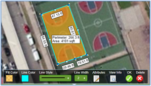
A significant improvement was made to the Measure Tool supporting more detailed measurements. The measure tool can be accessed through the Drawing Tool or from the Command list associated with each layer window.
|
|
|
Visit the links below to learn more about these new features:
Drawing Tools | Thematic Mapper | Measure Tool | Create Layer | Add Notes | Attach Documents
|
|
|
Version 8 of CityGIS™ enhances the accuracy of address locations and provides auto-complete functionality when entering addresses. Only addresses in the municipality and within a buffer around the municipality are included in auto-complete results.
In response to customer feedback, DMP improved the process and management of adding addresses within CityGIS™ Version 8. You can now add addresses by locating the address or from the property information window.
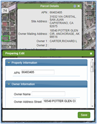
Additionally, CityGIS™ Version 8 provides you the ability to edit and enhance parcel attributes. The ability to edit parcel attributes is beneficial if a parcel is sold or the address information is incomplete (eg. government owned property) then you can add property attributes such as Owner Name, Address, Site Characteristics and Sale Information.
|
|
|
Visit the links below to learn more about these new features:
Using Locate | Address Management Workflow
|
|
|
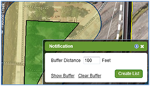
Version 8 of CityGIS™ provides you with an easier to use Buffer tool. The Buffer/Notification tool can be accessed from a property in the Window Commands or can be activated from the Commands associated with any layer or markup. So you can create a buffer 750 feet from a City Park or 100 feet from a manhole or sewer line.
As part of the Notification Workflow, you have the option of creating Address Labels or Export to Mail Merge. Address labels have been enhanced to include Owner, Mailing Address or Both.
|
|
|
Visit the links below to learn more about these new features:
Notification Workflow
|
|
|
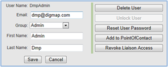
The CityGIS™ Version 8 platform empowers you to control and manage many features in the application. A few of the key Administrative tools and features include:
- Set up / manage users
- User password retrieval and reset
- Define permissions for users
- Customize account specific data
- Customize search forms
- Customize map views
These new features allow you to take control of your account, users and data.
|
|
|
Visit the links below to learn more about these new features:
Administration Module | Account Admin Setup
|
|
|
ENHANCED DATA LOADING AND PUBLISHING
One of the major improvements in Version 8 of CityGIS™ is the ability for you to publish your data to CityGIS™ and CommunityView™. When data is loaded to CityGIS™, the user styles the layer, adds any labels, and then chooses whether to publish and share the data layer with the entire account, a group or into CommunityView™. In Version 8, you are able to load GIS shapefiles, address spreadsheets, coordinate data as well as spreadsheets to link to existing data in CityGIS™.
|
|
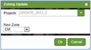
IMPROVED ZONING EDITOR
Zoning Editor is a built-in tool that allows cities to change individual parcels or zones through an interactive set of menus within CityGIS™ Version 8. Share your changes with other staff for approvals, add notifications to remind you to check on the project status or to publish the changes to the entire account. With a re-designed workflow-driven process, Zoning Editor should be a part of every City's Zoning update process.
API SUPPORT AND INTEGRATION OPPORTUNITIES
CityGIS™ is built on an open platform with supported APIs allowing for integration and data synchronization opportunities with other vendor solutions and data. The entire application of CityGIS™ was created to serve as an implementation platform.
For more information on data synchronization and platform integration opportunities please contact our Customer Success Team at (888) 322-6277 ext 2
|
|
|
Visit the links below to learn more about these new features:
Zoning Editor | Data Loader | Publish To CommunityView
|
|
|
CityGIS™ Version 8 is completely browser plug-in free (no Java or enhanced print plug-ins) and works across multiple browsers and platforms.
Click here to learn more about system recommendations.
|
|
|