|
LandVision
Help >
What's New > Summer 2017 Release
|
|
Welcome to the Summer 2017 release of your LandVision Edition. With this release comes:
- Microsoft Update
- Market Insight Tools
- New Data
- General Usability
- LandVision Connect for CRE Updates
- Data Updates that you've experienced over the past few months
Keep reading below for more details on what's new in the LandVision Summer 2017 release and for links to additional information on how to use these new features.
|
Microsoft Bing 8 Update
All LandVision Editions are now on the latest version 8 of Bing Maps. Noticeable enhancements from Microsoft include:
- Street Labels will now be visible on top of custom imagery, TimeView, and some other layers
- Improved performance on mobile applications
- New oblique imagery accessed with the Birds Eye View command, sourced by Microsoft, with improved quality and increasing geographic coverage
|
|
|
Expanded Market Insight Tools
Expanded Trade Areas Functionality
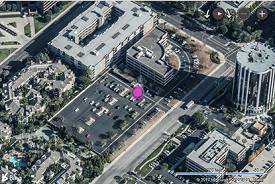
Now you can generate Trade Areas on every record from a Results List made up of points. Take advantage of this new functionality to quickly gain spatial insight into market opportunities and competitive gaps.
Pictured: 0.25 and 0.5 mile rings generated from a list of universities. The star represents an acquisition opportunity for student housing.
*Trade Areas are only available in the LandVision Builder Developer and Commercial Real Estate Editions.
Visit the link below to learn more about this feature:
Trade Areas
|
|
|
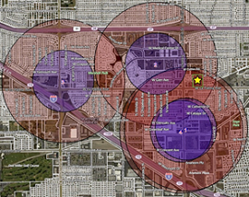
Understand the Data with Our New Heatmaps!
Get a better understanding of the density of data in your area with our new Heatmap command. Generated from any layer, this command will create a second layer that allows for a quick assessment and quantification of information.
Visit the link below to learn more about this feature:
Layers Panel | Heatmaps
|
|
New Data
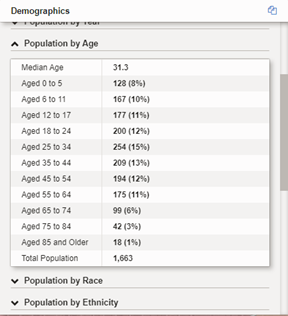
Updated Demographics
Our Demographics layer has ten new cards, containing nearly 100 new data fields! Leverage this updated information to improve your understanding of the market, enhance your analysis, and discover the best opportunities.
The new cards include:
- Population by Age
- Households by Income
- Families by Income
- Education Attainment
- Households by Year
- Housholds by Inhabitants
- Employment Travel Time
- Rent Prices
- Crime Information
- Retail Sales ($)
Visit the link below to learn more about this feature:
Demographics
|
|
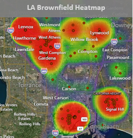
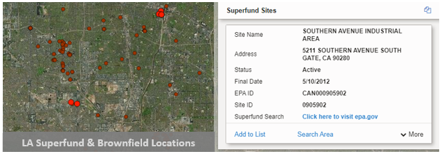
Environmental (Man-Made) Hazards
We've added two new layers to LandVision Commercial Real Estate and Builder Developer Editions. The new layers include one representing Brownfields, while the other represents Superfund Sites. Check these out today and get a better understanding of nasty property issues that may impact your project.
|
|
General Usability
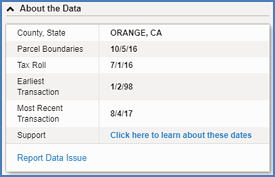
New About the Data Card
Presented as a card for every property, About the Data provides the following information:
- Vintage of the parcel boundary data. This represents the currency, defined by the version date, of the property characteristics.
- The Tax Roll date, which represents the county release date for the tax roll.
- The most recent date of recorded property transactions for the county. This includes updated property records with new ownership, sales dates, and transaction details.
- When property transactions updates from County Recorder offices were first captured into the Transaction History of properties in the County.
- Our new Report data Issue command allows you to log a data issue with our support team without leaving the product.
Visit the links below to learn more about this feature:
Panels & Cards | About the Data
|
|
Updated Results List Options

You've asked for it and we're delivering. Prior to the implementation, the Results List had to be removed in order to see the properties that were covered by numbers. With this new implementation it can be done (while retaining the highlight) without removing the results list.
Visit the link below to learn more about this feature:
Results List
|
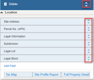
Card Designer Enhancements
Card Designer has been improved to easily allow for the re-ordering of Cards and Fields. Just click the arrow to the right (higlighted) to move the information in a manner that best meets your needs to more easily browse and understand the information presented.
Visit the links below to learn more about this feature:
Card Designer | Commands
|
|
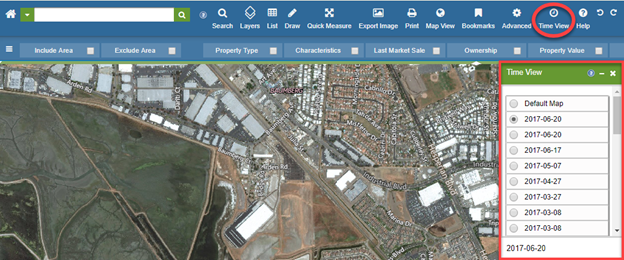
TimeView Has A New Home
One of our most popular premium features, TimeView, can now be found in the Toolbar. Using this command will now generate a movable window to allow for easy access when viewing changes to your market over time.
Visit the link below to learn more about this feature:
TimeView | Toolbar
|
Document Images Update
Document Images have received an update which has improved our match rate significantly.
Note: Document Images is a paid add-on for all products.
Visit the link below to learn more about this feature:
TimeView | Toolbar
|
|
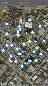
Connect for LandVision Commercial Real Estate Edition Update
|
Based on our user's feedback we have added:
- Availability for download from both, the Apple App Store and the Google Play Stores
- Parcel boundaries are now visible when viewing the map
- A new icon will indicate where you are located on the map
- The map will now zoom to your location when you click the Find Me button, found to the right of Locate
Note: If you are using an iPhone and have previously installed Connect for LandVision CRE, you must uninstall the previous version prior to installing the latest version from the Apple App Store.
Visit the link below to learn more about this feature:
Connect for LandVision CRE | MySites
|
|
Data Updates
|
While our customers have been awaiting the latest release of LandVision, they have already had the benefit of experiencing the following updates:
- Over the past 12 months, DMP has sourced, secured, and processed parcel geometry updates from Counties covering over 55 million parcels.
- Over 2.5 million new parcels totaling over 100 new counties have been added into the LandVision application platform in the past 12 months!
- Tax information has been updated for over 2,600 counties.
- The Builder Sites information has been updated for 2017 and now includes an additional 50 builders, now totaling 300.
|
|
|
|
|
© Copyright 2018 Digital Map Products
|
|
