
|

|
INTRODUCING GovClarity®
| GovClarity® Help > What's New > GovClarity | |
|
GovClarity® is an all new mapping and integration platform designed to improve government efficiency and constituent service. It is the next generation version of Digital Map Products' popular CityGIS™ software and includes all your favorite CityGIS™ features, along with a brand new interface and powerful new features and integration capabilities. With this release, CityGIS™ is now GovClarity®.
Designed around common local government workflows, GovClarity® automates complex departmental tasks through built-in tools and features. Built on the popular Microsoft Bing Maps platform, you'll be able to jump right in and navigate the map with familiar navigation tools that allow for quick access to critical information and a common place to integrate all your agency's spatial and property data. Managing your data in GovClarity® is easy through the built-in data loader tool which provides your account immediate access to the loaded data as well as the ability create, edit and maintain data layers, all from within GovClarity®. GovClarity® has powerful search tools configured for local government use. In addition to the pre-configured searches, you can create custom searches on any layer in your account. GovClarity® provides easy ways to customize and configure the platform to meet your needs. Department modules for both Planning and Public Works provide deep functionality and tools which improve the efficiency of everyday tasks. Through GovClarity® APIs and data synchronization, you can ensure key datasets and functionality are maximized across software platforms and tools. Several powerful constituent engagement tools are part of GovClarity® including a mobile citizen Issue Reporting application and CommunityView™. With CommunityView™, local governments can share data with the public through a web-based mapping tool. |
Searching and Results List
|
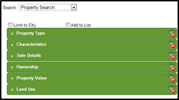
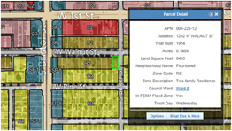
Search capabilities in GovClarity® are flexible and designed around the user including on-the-fly modifications, dynamic results, and auto-complete. Advanced searches are located in one menu including Property Search and Property Sales, which let you define your search criteria by site characteristics, owner name, assessed value and even limit your searches to specific areas such as City Boundary. Additionally, you can create your own custom searches and limit those based on drawn areas, circles or buffered areas.
The Results List empowers you with options to interact with the data in GovClarity®, print, export, or even create address labels from property data. |
|
|
Visit the links below to learn more about these new features: Property Search Filter | Results List | Create Filter | Using Locate |
|
Working with your Data
|
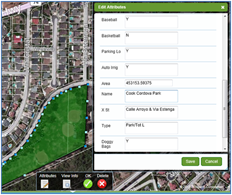
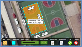
Managing your data in GovClarity® is easy through the built-in data loader tool which provides your account immediate access to the loaded data as well as the ability create, edit and maintain data layers, all from within GovClarity®. Through the Drawing Tools, you can choose any existing Agency layer to draw new points, lines or areas and can then add associated feature attributes. Similarly, you can create new layers through the drawing tool as well. Through these new features, you are empowered to maintain and create layers based on your job responsibilities and knowledge which maximizes efficiency and minimizes error.
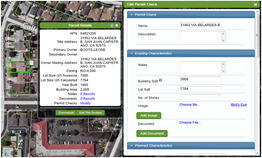
Through the Add Notes and Documents features you are able to link data directly to a parcel or address for anyone in your local government to see. Lastly detailed and accurate measurements can be completed on any layer or drawn graphic. |
|
|
Visit the links below to learn more about these new features: Data Loader | Drawing Tools | Thematic Mapper | Measure Tool | Create Layer | Add Notes | Attach Documents |
|
Automated Departmental Tasks
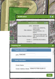
| Creating buffers around parcels or custom drawn graphics is easy with built-in buffer tools allowing you to quickly create a 750ft buffer around a city park or 100ft from a manhole or sewer line. As part of the Notification workflow, you have the option of creating Address Labels or Export to Mail Merge. Address labels include the ability to create labels for the owner, mailing address/occupant or both. |
|
|
Through GovClarity® you can easily add missing addresses or edit and enhance existing property information. The ability to edit parcel attributes is beneficial if a parcel is sold or the address information is incomplete (eg. government owned property) then you can add property attributes such as Owner Name, Address, Site Characteristics and Sale Information.
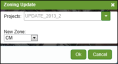
Zoning Editor is a tool that allows cities to change individual parcels or zones through an interactive set of menus within GovClarity®. Share your changes with other staff for approval, add notifications to remind you to check on the project status or to publish the changes to the entire account. With workflow-driven processes, Zoning Editor should be a part of every City's Zoning update process. |
|
|
Visit the links below to learn more about these new features: Notification Workflow | Address Management Workflow | Zoning Editor |
|
Constituent Engagement Tools
|
GovClarity® was built designed to ensure seamless integration and update of your constituent engagement efforts. Through CommunityView™, a web-based mapping platform, you can easily share data in GovClarity® with the public. CommunityView™ provides you with the flexibility of embedding the product across multiple areas of your website, each with the option of a different map theme or focus. For example, you could create a zoning map to display in the Planning Department webpage or you could create a Street Sweeping or Trash Pickup map for Public Works. Your constituents are able to self serve their needs and quickly access the information they want through CommunityView™.
A citizen Issue Reporting mobile application is paired with GovClarity® allowing for data analysis, work order creation and management. Through the mobile application, citizens can submit issues across the community which are then managed through GovClarity® and can even be displayed on CommunityView™. |
|
|
Visit the links below to learn more about these new features: CommunityView | Issue Reporting |
|
Departmental Modules
The Planning Module includes deep functionality designed to improve the efficiency of planning departments. The Planning Module includes three key features;
The Public Works Module utilizes mobile technology and a work order system to create a powerful fixed asset inspections management system.
|
|
|
Visit the links below to learn more about these new features: Zoning Analysis | Permit Check | Property Setback Tool | Inspections Management |
|
Account Administration and Customization
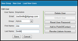
GovClarity® puts account administration and control in your hands. A few of the key features associated with Account Administration include:
These features allow you to take control of your account, users and data. GovClarity® is a cloud-based and open platform which enables easy integration and data synchronization across other departmental tools. The entire GovClarity® platform was created to serve as an integration platform. GovClarity® includes full API support, samples, documentation and integration consultants to guide you through the process of improving system efficiency. |
|
|
Visit the links below to learn more about these new features: Administration Module | Account Admin Setup |
|
Return to Top |
| © Copyright 2018 Digital Map Products | About DMP | Contact Us |